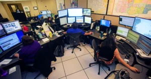
In emergency response, seconds matter—and where every second counts, knowing where your resources are is critical. Fire Dispatchers rely on more than instinct and radio updates; they need precise, up-to-the-moment information to make life-saving decisions. That’s where AVL (Automatic Vehicle Location) and GIS (Geographic Information Systems) come in.
Together, these technologies paint a real-time digital picture of unit locations, street-level data, fire hydrant placements, hazards, and more. For Dispatchers, it’s a game changer—especially during fast-moving fires, mass casualty incidents, or overlapping calls.
In this post, we’ll explore how AVL and GIS systems work hand-in-hand to improve deployment accuracy, reduce response times, and support strategic fireground operations. We’ll also spotlight real-world examples and provide helpful tools to bring this knowledge back to your own center.
What is AVL and How Does It Work?
AVL, or Automatic Vehicle Location, uses GPS technology to track the real-time position of emergency vehicles. Fire apparatus equipped with AVL transmit their location back to the dispatch center, allowing Dispatchers to:
- Monitor fleet movement live
- Select the closest available unit
- Coordinate multi-unit responses with precision
What is GIS in a Fire Dispatch Context?
GIS is a digital mapping system layered with data such as:
- Street layouts
- Building footprints
- Fire hydrant locations
- High-risk occupancies
- Response district boundaries
Unlike static paper maps, GIS is dynamic and customizable, allowing centers to display mission-critical data tailored to each incident.
How the Two Systems Integrate
When AVL data is overlaid on GIS maps:
- Units appear as live-moving icons on a smart map interface.
- Dispatch decisions are driven by both location and operational intelligence (e.g., road closures, hazards, or route restrictions).
- Command staff can track units not only by address but by geographical context—crucial during wildfires or large-scale incidents.
Real-World Example: San Ramon Valley Fire Protection District (California)
The San Ramon Valley Fire Protection District uses AVL/GIS integration within their dispatch and CAD systems to:
- Automatically recommend the closest unit with the required capabilities
- Display unit locations on shared command maps accessible in the field
- Overlay high-priority EMS calls with demographic and incident trend data
This led to response time improvements of nearly 30 seconds per call, a critical difference in cardiac or respiratory emergencies.
Dispatcher Advantages
AVL and GIS empower Dispatchers to:
- Avoid blind spots in unit tracking
- Mitigate duplication of response
- Provide live updates to command staff
- Coordinate regional mutual aid based on geography, not assumption
Fireground Benefits
- ICs receive enhanced pre-arrival situational awareness
- Routes can be modified mid-response due to traffic or hazards
- Resource staging can be optimized based on terrain and unit proximity
Potential Challenges
- Data overload: Too many layers or cluttered maps can hinder clarity.
- Training gaps: Dispatchers and firefighters need ongoing training to maximize the tech.
- Inter-agency differences: Not all systems are interoperable between jurisdictions.
Related Reading:
- Cloud Computing in Fire Services: Enhancing Data Accessibility and Collaboration
- Data-Driven Decision Making: How Dispatch Centers and Fire Services Utilize Big Data
Conclusion
AVL and GIS aren’t just buzzwords—they’re mission-critical technologies that are reshaping modern fire response. When used together, they provide Dispatchers and Incident Command with the tools they need to make informed, strategic decisions, even in rapidly evolving environments.
Whether you’re looking to shorten response times, reduce scene chaos, or support multi-agency collaboration, this technology pairing offers a measurable path forward. It’s not about replacing the human element—it’s about equipping our people with smarter tools.
If your center isn’t using AVL and GIS together, now is the time to ask why. And if you are, make sure you’re using them to their fullest potential.
➡️ Want more content like this? Subscribe to The Alarm Room for actionable tools, trusted insights, and dispatch-centered support.